VOLCANO TYPES
CINDER CONE
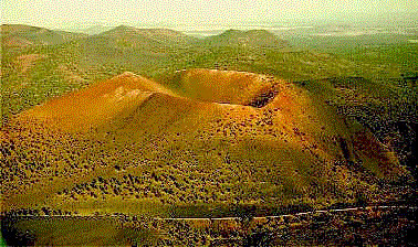
Figure 1. Sunset Crater, Arizona
A cinder cone is pile of loose rock fragments
which have been ejected from a volcano vent. Gas pressure which
builds up below the surface propels the fragments.
Sunset crater in Arizona is an example.
Krakatoa in Indonesia is another example.
COMPOSITE VOLCANO (or STRATOVOLCANO)
A composite volcano is constructed from
alternating layers of pyroclastics and rock solidified from lava
flows. Pyroclastics are fragments of rock formed by volcanic
explosions.
Composite volcanoes have thick, viscous
lavas. These lavas can form plugs at the top of the volcano.
The plugs allow gas pressures to build up to high levels. Thus,
these volcanoes often suffer explosive eruptions.
A composite volcano is also called a stratovolcano.
Examples of composite volcanoes are Mount Fuji, Mount St. Helens,
and Pinatubo.
St. Helens and Pinatubo have each had
catastrophic eruptions during the last 20 years.
SHIELD VOLCANO ( or LAVA CONE)
Shield volcanoes have gentle slopes. The
slopes are gradual because the lavas have low viscosities and
come out at high eruption rates. Low viscosity means that the
lava is thin and runny. Theses lavas flow rapidly downhill and
cannot build steep slopes.
The planet Mars has giant shield volcanoes,
much bigger than any volcanoes on Earth.
The Belknap volcano in Oregon is an example
of a shield volcano. The Hawaiian volcanoes are also shield volcanoes,
particularly Kilauea and Mauna Loa.
|
WORST VOLCANO ERUPTIONS
TAMBORA VOLCANO
The islands of Indonesia are one of the
most active volcanic areas in the world. These islands were once
known as the Dutch East Indies.
The Indonesian island of Sumbawa is east of Java. The Tambora
volcano is on this island. The Tambora volcano in 1815 spewed
forth so much ash that 1816 was know as the "year without
a summer." Snow fell in New England in June and frost covered
the southern United States on the fourth of July.
The Tambora explosions blew about 35 cubic miles of debris over
the surrounding area. The mountain height was reduced from 13,000
feet to 9000 feet. According to the Encyclopedia Britannica,
the Tambora volcano was the worst volcano in historical times.
KRAKATAU
Another notable eruption was the Krakatau eruption in 1883. Krakatau
was an island located near the Indonesian island of Sumatra.
Krakatau was once an island the size of Manhattan. It destroyed
itself over a number of eruptions. Four separate islands were
formed as a result: Krakatau, Perbiewatan, Dana, and Rakata.
The only island to remain after the 1883 eruption was Rakata.
The 1883 eruption produced an ash cloud which circled the world
for over two years. Temperatures became colder as a result, reducing
crop yields.
At least 36,000 people died as a result of the 1883 Krakatau
eruption. Some of these people were killed by tsunami waves.
|
HAWAIIAN VOLCANOES
The topsoil on the Hawaiian Islands is
composed mainly of volcanic material, along with some coral material.
The Hawaiian Islands were formed by volcanoes,
some of which are still active. The lava is composed of basalt,
which is the material that underlies the ocean floor.
Mauna Loa is the largest volcano on the
Earth. It makes half of the area of the Big Island of Hawaii.
Its last eruption was in 1984.
Kilauea is an active volcano on the Island
of Hawaii. Its present-day caldera formed in 1790 A.D. Kilauea's
current eruption began in 1983.
Kilauea is a shield volcano. Shield volcanoes
have gentle slopes. The slopes are gradual because the lavas
have low viscosities and come out at high eruption rates. Low
viscosity means that the lava is thin and runny. Theses lavas
flow rapidly downhill and cannot build steep slopes.
Loihi is the youngest of the Hawaiian
volcanoes. It is a "seamount volcano," 22 miles southeast
of the Big Island. In other words, Loihi is submerged beneath
the ocean surface.
The summit of the Loihi volcano is 3,178
feet (969 m) below sea level. It contains a caldera depression.
Loihi could become an island, but this process would take thousands
of years.
Loihi was discovered in 1954, along with
four other seamounts: Papa`u, Wini, `Apu`upu`u, and Hohonu.
Loihi is an active volcano. During the
summer of 1996, the largest swarm of earthquakes ever recorded
on any Hawaiian volcano shook Loihi seamount. The swarm began
on 17 July 1996.
Geologists are using manned-submersibles
to study Loihi.
|
MOUNT ST. HELENS
Mount St. Helens is a composite volcano,
also called a stratovolcano.
A composite volcano is constructed from
alternating layers of pyroclastics and rock solidified from lava
flows. Pyroclastics are fragments of rock formed by volcanic
explosions.
Composite volcanoes have thick, viscous
lavas. These lavas can form plugs at the top of the volcano.
The plugs allow gas pressures to build up to high levels. Thus,
these volcanoes often suffer explosive eruptions.
Mount St. Helens is located in the southern
part of Washington State. It has erupted many times throughout
history.
For example, it erupted in 1842 and remained
active until 1857.
It resumed activity on March 25, 1980.
Small earthquakes occurred followed by steam-blast emissions.
The major eruption occurred on May 18,
1980. A magnitude 5.1 earthquake at 8:32 a.m. PDT triggered the
violent eruption. The entire north face of the mountain was blown
away. This caused a landslide with a volume of material equal
to 2.3 cubic km (0.56 cubic miles).
|
MOUNT PINATUBO
Mount Pinatubo in the Philippine island
of Luzon.
Mount Pinatubo is a composite volcano, also called a stratovolcano.
Composite volcanoes have thick, viscous lavas. These lavas can
form plugs at the top of the volcano. The plugs allow gas pressures
to build up to high levels. Thus, these volcanoes often suffer
explosive eruptions.
One of the most important facts about the 1991 Mount Pinatubo
volcanic eruption is that geologists were able to predict the
eruption.
Geologist monitor volcanoes using a variety of instruments, in
order to predict eruptions.
Seismometers are used to measure the Earth's vibration. Inclinometers
are used to detect changes in the slope of the land. Thermometers
are used to measure temperature changes. Other gauges measure
traces of sulfur dioxide and other gases.
Geologists using these instruments successfully predicted the
eruption of Mount Pinatubo in 1991. Mount Pinatubo's volcanic
activity began on April 2. The main eruption occurred on June
15.
Warnings were sent out to people living near the volcano. As
a result, thousands of people were saved because they were able
to evacuate their homes before the main eruption. Even so, 847
people died.
Mount Pinatubo's ash cloud formed a band which circled the Earth's
equator. The Earth's average temperature cooled by 1 degree Celsius
as a result.
|